
Central Estuary Restoration Project Update - June 2023:
Understanding tides and the training berm modification
Shortly after the modification of the Lower training berm was completed mid May, team members, May, Edith and Patty, went down to see it at high tide as our engineers were scheduled to do a bathymetric survey of the area. It was a sight to behold as the nutrient-rich fresh water mixed with the incoming tide to inundate the area just south of the former yellow gate creating a gentle current flowing north east back into the central estuary. As the sun slipped behind the Tantalus range and the last kite boarder eked out the final wind of the day, an otter patrolled this new habitat just 30 feet from the new end of the berm; a good omen and perhaps an indication that juvenile salmonids were successfully finding their way into the nursery of the central estuary.
Not since 1971 have Juvenile salmon been able to migrate this freely from the Squamish River into the central estuary where they find shelter, feed on abundant nutrition and go through the complex physiological process of smoltification that helps them transition successfully from the fresh water of their natal river to life in the salty sea. And now, with phase II of the Central Estuary Restoration Project in the history books (as they say), and 850 metres of the former training berm removed, juvenile salmon can now access the Squamish River Estuary almost two kilometres closer than before without exposure to the dangerous open waters of Howe Sound.
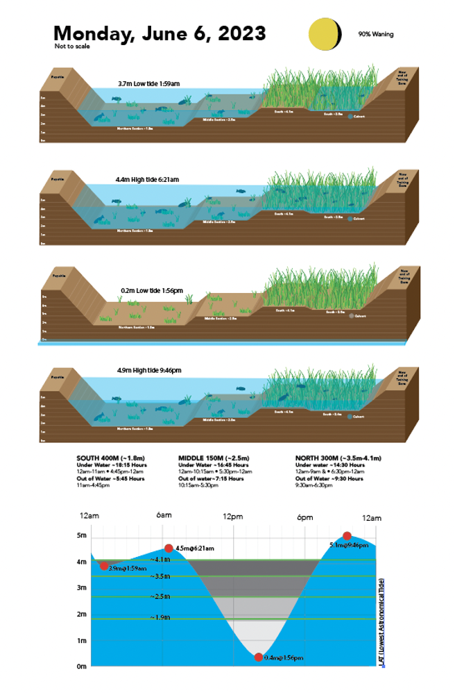
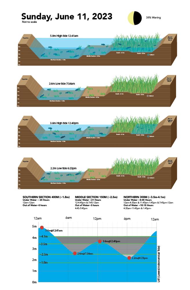
The estuary is of course tidal and it changes with every moment. When the tide flows into the estuary it first crests the most southerly 450 metres of the former berm at 1.8 metres (LAT-Lowest Astronomical Tide). Like a slow-filling bathtub, the tide continues to rise above 2.5 metres and another 150 metres of the former training berm starts to disappear under the brackish waters. At this mid point along the former berm, the removal starts to follow the topography of the adjacent sedge marsh and sand bank on the river side, varying in height from about 3.5-4.1 metres. This most northern part of the modification will be planted with grasses and sedges further enhancing the biodiversity of the area. And when the tide reaches this height, the flows of the river and tide spread over the large sandbars in the river and submerge the sedges and grasses of the tidal flats in the estuary.
To help the general public better understand the dynamic and ever-changing tidal influences on this new habitat, we’re developing some graphics that will be loaded to our restoretheshore.ca website. See below.
Not since 1971 have Juvenile salmon been able to migrate this freely from the Squamish River into the central estuary where they find shelter, feed on abundant nutrition and go through the complex physiological process of smoltification that helps them transition successfully from the fresh water of their natal river to life in the salty sea. And now, with phase II of the Central Estuary Restoration Project in the history books (as they say), and 850 metres of the former training berm removed, juvenile salmon can now access the Squamish River Estuary almost two kilometres closer than before without exposure to the dangerous open waters of Howe Sound.
The estuary is of course tidal and it changes with every moment. When the tide flows into the estuary it first crests the most southerly 450 metres of the former berm at 1.8 metres (LAT-Lowest Astronomical Tide). Like a slow-filling bathtub, the tide continues to rise above 2.5 metres and another 150 metres of the former training berm starts to disappear under the brackish waters. At this mid point along the former berm, the removal starts to follow the topography of the adjacent sedge marsh and sand bank on the river side, varying in height from about 3.5-4.1 metres. This most northern part of the modification will be planted with grasses and sedges further enhancing the biodiversity of the area. And when the tide reaches this height, the flows of the river and tide spread over the large sandbars in the river and submerge the sedges and grasses of the tidal flats in the estuary.
To help the general public better understand the dynamic and ever-changing tidal influences on this new habitat, we’re developing some graphics that will be loaded to our restoretheshore.ca website. See below.
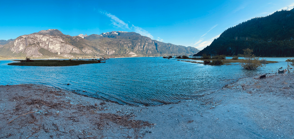
It was about 6pm Saturday June 3 when we took in this wonderful sight. We are standing where the yellow gate used to be. The tide was about 4.5 metres and still flooding toward a 7:22pm high tide of 4.8 metres.
|
|