Background
|
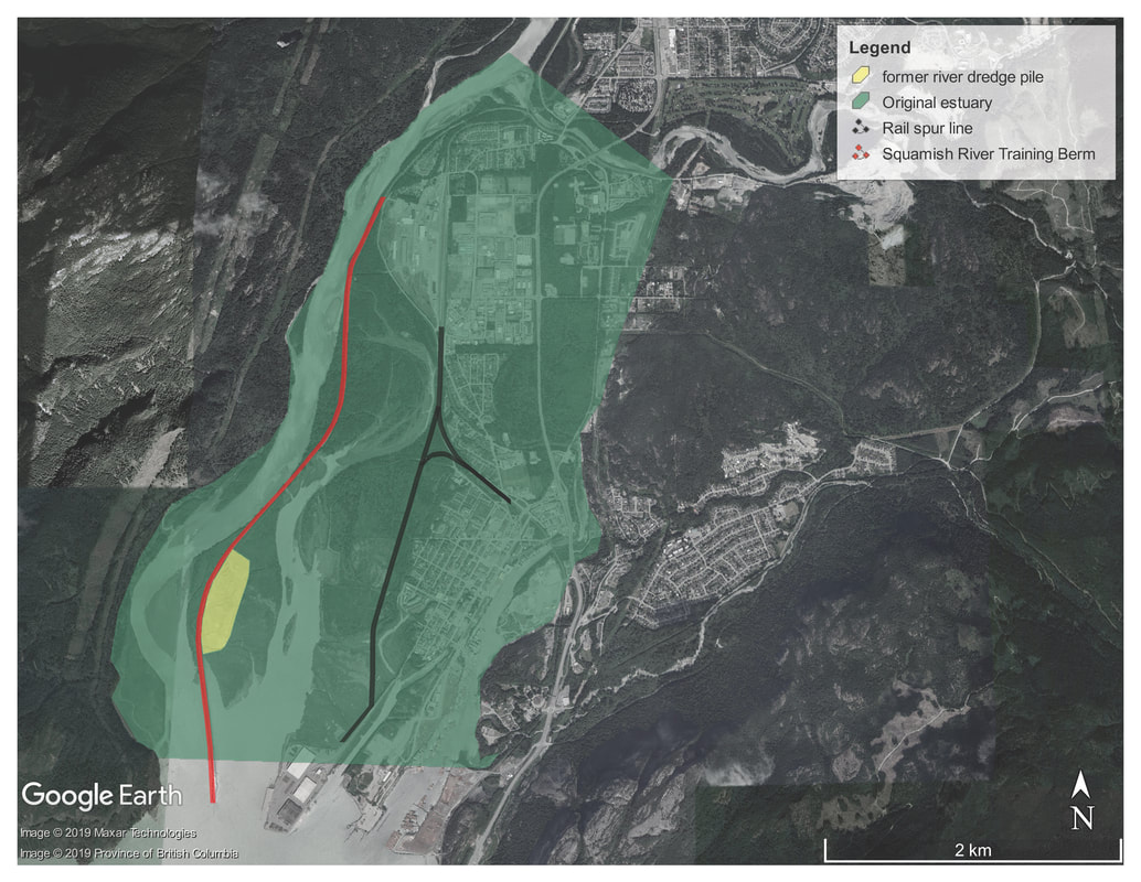
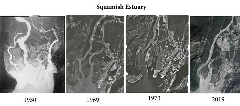
Historically the Squamish River flowed from west to east across the estuary flood plain, and the Mamquam River drained in to estuary habitat in what is now known as the Mamquam Blind Channel. In recent years the lower flood plain has been drastically altered to accommodate development.
In the 1970s the rail spur line and Squamish River training berm, known locally as the ‘spit road’ were built on the western and eastern sides of the central estuary limiting water flow and habitat function in this area. The rail spur line that services the deep sea port was built across tidal channel isolating those in the Bridge Pond area from their top end flow. The training berm was built to ‘train’ or channelize the Squamish River to the west, isolating it from the estuary flood plain. There were plans at the time to build a coal export facility in the Central Estuary, and following construction of the berm the lower Squamish River was dredged to accommodate large ships. The river dredegate was used to preload the proposed coal port facility site, burying 15 hectares estuary under a large pile of sand, silt and cobble. |
Following public concern over the continued industrialization of Squamish’s waterfront, the Federal-Provincial Squamish Estuary Management Planning (SEMP) process to realize a balanced approach to waterfront development started in the late 1970s. An outcome of the SEMP process was a decision to limit further development in the remaining estuary and while the coal port was not permitted, the training berm and dredge pile remained. The Central Estuary was isolated from from freshwater flow and sediments, buried under a pile of fill and remained this way until the late 1990s.
The SEMP that started in the late 1970s was signed in 1999 by the Federal, Provincial and Local governments designating conservation, industrial/commercial, transportation land use areas, and recommended that the Mamquam Blind Channel be further assessed before designating acceptable land uses (figure 1). The SEMP also identified restoration measures within the conservation area, and an inter-jurisdictional project review process to ensure that proposals maintained the intent of the land use designations.
Starting in 1999 the SRWS in partnership with Squamish Nation, Fisheries and Oceans Canada, the Province of BC and others led restoration projects in the estuary, and as of 2015 substantially completed all of the restoration measures identified in the SEMP including:
In 2007 the SEMP conservation area was designated as a Provincial Wildlife Management Area, and Squamish Nation acquired Site A. Site A is adjacent to the Wildlife Management Area with unique habitat features including mature upland forest with significant trees. The Wildlife Management Area and Site A is co-managed by the Province of BC and Squamish Nation in accordance with the Skwelwil’em Squamish Estuary Management Plan (figure 2)
In 2008 the Nature Trust of BC purchased the parcel estuary habitat in the Bridge Pond area, that is contiguous with Site A and the Wildlife Management Area on the east side of the rail spur line (figure 3). The parcel is isolated from the Central Estuary by the rail spur line, and tidal channels across the property are partially inundated with storm water, tidal influx from Cattermole Slough (regulated by the tide gate). Channel isolation, point source pollution from storm water runoff and other factors have impacted water and habitat quality in the Bridge Pond area.
The restoration measures proposed under CERP build on 20 years of habitat restoration in the estuary, and are informed by the SRWS’s monitoring program to address the ongoing impacts of the training berm and rail spur line in the Estuary. They were developed in consultation with our project partners - Fisheries and Oceans Canada & Squamish Nation and include the following (figure 4):
The SRWS supports a collaborative approach to project planning and implementation, and in past worked through the SEMP process to achieve this. SEMP however has been relatively inactive since 2012 when the Federal and Provincial Government withdrew from this process. To address this gap the SRWS has convened a CERP stakeholder working group who provide regular input on project planning and implementation.
Starting in 1999 the SRWS in partnership with Squamish Nation, Fisheries and Oceans Canada, the Province of BC and others led restoration projects in the estuary, and as of 2015 substantially completed all of the restoration measures identified in the SEMP including:
- Installation 4 of the 9 existing culverts and trash racks across the training berm.
- Remove the river dredge pre-load material from the Central estuary and restore 15ha of salt marsh, tidal channels and upland habitat.
- Decommission the former log sort and access road in the estuary are restoration of 5ha of salt marsh, tidal channel and upland habitat.
- Construction of over 25,000 m2 of tidal channel habitat and restoration planting
- Restoration of eelgrass beds (Zostera marina)
- Construction of pedestrian bridges throughout the estuary trail network
- re-watering of channels in the Mamquam River watershed
In 2007 the SEMP conservation area was designated as a Provincial Wildlife Management Area, and Squamish Nation acquired Site A. Site A is adjacent to the Wildlife Management Area with unique habitat features including mature upland forest with significant trees. The Wildlife Management Area and Site A is co-managed by the Province of BC and Squamish Nation in accordance with the Skwelwil’em Squamish Estuary Management Plan (figure 2)
In 2008 the Nature Trust of BC purchased the parcel estuary habitat in the Bridge Pond area, that is contiguous with Site A and the Wildlife Management Area on the east side of the rail spur line (figure 3). The parcel is isolated from the Central Estuary by the rail spur line, and tidal channels across the property are partially inundated with storm water, tidal influx from Cattermole Slough (regulated by the tide gate). Channel isolation, point source pollution from storm water runoff and other factors have impacted water and habitat quality in the Bridge Pond area.
The restoration measures proposed under CERP build on 20 years of habitat restoration in the estuary, and are informed by the SRWS’s monitoring program to address the ongoing impacts of the training berm and rail spur line in the Estuary. They were developed in consultation with our project partners - Fisheries and Oceans Canada & Squamish Nation and include the following (figure 4):
- Upgrade existing culverts in the training berm to improve fish access
- Modify the lower section of the training berm to reconnect the lower estuary
- Install a flow control device under the CN rail spur to re-water historical channel
The SRWS supports a collaborative approach to project planning and implementation, and in past worked through the SEMP process to achieve this. SEMP however has been relatively inactive since 2012 when the Federal and Provincial Government withdrew from this process. To address this gap the SRWS has convened a CERP stakeholder working group who provide regular input on project planning and implementation.


